History of Qasr El Labkha in El Kharga Oasis
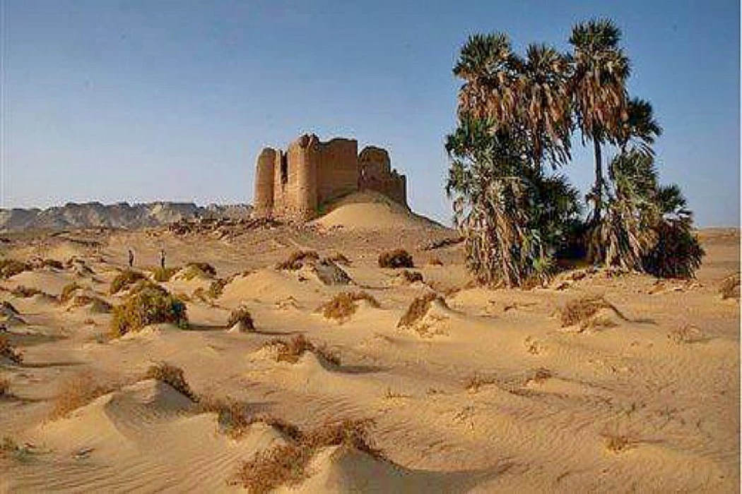
About 35 kilometers northwest of the Kharga oases in the New Valley governorate, the area of Al-labkha and Umm Al-dabadeb are the two archaeological sites, which date been to the Roman era. It was a large city that depended on irrigation systems through irrigation channels under the mountains. They established temples, a fortress for guarding, dwellings and an area for burying the dead, an area located on the It is completely isolated and has no mobile networks, which is what amateurs want to get out of the city atmosphere, traffic and living an atmosphere The charming nature and unusual tranquility, in addition to discharging negative energy charges, according to what most of the pioneers of this unique region felt.
This area was called Umm Al-dabadab because it was a region full of good deeds. It was full of all kinds of animals and not devoid of them at all, which was attributed to her from the name Umm Al-dawab, and the name was gradually distorted to Umm Al-dabadab, and the ficus area was named by this name due to the spread of ficus trees in it, which are trees with many medical benefits. The area contains fortresses and castles with paths for soldiers and openings used to throw arrows and pour boiling water and oil on the enemies in the event of an attack on the castle, as well as stairs to climb to the soldiers 'quarters and spread around commercial and administrative facilities, soldiers' houses and their families and stores that used to serve commercial caravans passing on the road by supplying them with full supplies, the remains of which are still located next to the castle, which are the remains of adobe bricks.
The area can be reached by two roads, the first starts from kilo 17 from the Kharga-Dakhla road (dust trail) and then turns north to the East a little for about 40 kilometers in the mountain, and the second road is pestles that are traversed using SUVs, for these areas one of these roads is through the ficus area, which is the closest through the Ain Amor trail, but it is not available for cars to cross due to the spread of gorges and sandy hills, it has become semi-closed and is only suitable for walking and climbing on Sandy plateaus.
The Italian missions and Regiments discovered an astronomical phenomenon that occurs in the region during February every year, the Italians come to follow it in particular, which is represented in the appearance of the full moon disk after sunset directly above the two fortress buildings in the middle of them, and this is done at a fixed time at a specific time in minutes and seconds, which is known by astronomical calculations, and the region witnessed the visit of many foreign missions, including the American University mission as well as the mission of the Italian University of Milan and made an archaeological survey of the area and its surroundings to reveal the methods of Agriculture and irrigation in these periods and the quality of cultivated plants, etc.
The archaeological researcher Mohammed Ibrahim, Director General of the Kharga and Paris archaeological area in the governorate, said in a special statement to the" seventh day" that the archaeological area approved in Al-labkha and Umm Al-dabadab contains a large set of components and archaeological evidence of the ad and its area with its archaeological elements on an area of about 4 kilometers from North to South and about 1,5 kilometers from East to West is represented by two temples : The northern temple, the southern temple, a castle, a large fortress and the cabin of a wealthy man from the Roman era, named Peres, and it is believed that he was the ruler of the region or one of the nobles, and a large coward carved in the rock of the type of rock tombs and burials scattered in the Roman era, as well as a number of water vaults that run underground through channels carved in the rock called skylights, which is more than a skylight and more than a line, numbering about 14 lines, of which have been closed due to dust, air and climatic factors in the region, and some of them are still the existing one is working and has been disinfected so far.
Ibrahim added that there are still remnants of the residential city in the area, and large areas of agricultural land that were irrigated and cultivated in the old days, it is an integrated area of everything, a castle, a fortress, a cowardice, and a residential city with agricultural places and lands as the main craft in the old days, due to the presence of water skylights that deliver the water of the eyes, and the ficus fort was built in a valley at the base of the northern slope, and it served as a military garrison, it was strategically placed to guard the intersection of two important ancient caravan routes from the North and West, and the ficus Palace is a unique model built of bricks the 12-meter-high building includes four huge round towers in four corners, and the entrance to the palace is located on the east side, from which it is To the south there are the clay remains of a large well, an ancient spring, still surrounded by palm trees, acacias and dates, which used to provide water to the castle and the settlement. The size of the well indicates that a large community existed in the place in ancient times, it was fed by a series of aqueducts, which were created to transport water to cultivated fields.
Ibrahim confirmed that the temple was built of adobe bricks and is located to the north of the castle, on a natural outcrop that dominates the area and has an area of 12 square meters, it includes three rooms and probably dates back to the third century AD and includes drawings of the goddess Eagle (death) and some graffiti inscribed on both sides of the arch, and the second most destroyed temple, to the northwest of the castle, was discovered during the period from 1991 to 1992. This temple was completed during the reign of Antonius Pius and still contains some of its original paintings. The architecture of this temple is unusual and consists of a structure, partially built into the rock with the extensive remains of a brick building section to the front, several tombs have also been identified in the outskirts of the AL-labkha Palace, the most impressive cemetery is located in the area to the north of the castle, excavated in the western slopes where some of the most elaborate tombs have been found in the Oasis.
Ibrahim explained that many of these simple tombs consist of one room cut into the rock, next to many multi-room and decorated tombs, many of which contained burials, and about 500 mummies were evaluated and the majority looked good and some mummies of high-status individuals were covered with gilded face masks similar in style to Fayoum portraits, and many of them, especially the burial of women and children, contain richly decorated and painted with religious symbols, the burial equipment included large quantities of glassware.


